Topographical Surveyors
Trusted Topographical Surveyors with Proven Results
Get a Free Quote From Us Today!
We aim to get back to you in 24 hours.
At Topographical Surveyors, we provide specialist land measurement and mapping services to capture accurate data about terrain, features, and site conditions across the UK. This expert service focuses on delivering precise surveys that support planning, design, and construction for residential and commercial projects.
By identifying physical constraints and recording exact elevations, topographical surveyors ensure that architectural and engineering teams have a reliable geospatial foundation to prevent design errors and ensure project feasibility.
What Services Are Included When Hiring Topographical Surveyors?
Hiring topographical surveyors includes a comprehensive suite of data collection and processing activities designed to support every stage of the building design lifecycle:
- Site Feature Mapping – Recording the exact location of buildings, trees, fences, and manholes to provide a complete site overview for designers.
- Elevation and Level Surveys – Capturing height data and contours to ensure architects understand the drainage and accessibility constraints of the land.
- Boundary Demarcation – Establishing the legal limits of a property based on physical evidence to prevent encroachment disputes during the construction phase.
- Utility Infrastructure Integration – Overlaying underground service information onto surface maps to create a unified data set for safe excavation works.
- Digital Terrain Modelling – Producing high-fidelity 3D representations that allow for accurate volume calculations and architectural daylighting analysis.
Why Should You Choose Professional Topographical Surveyors?
Choosing professional topographical surveyors ensures that your project is built upon a foundation of absolute technical integrity and geospatial accuracy. Our experts use regularly calibrated instrumentation and hold specific indemnity coverages that unvetted providers lack, which minimises the risk of building over boundaries.
This expert oversight maximises project efficiency, providing a clear audit trail and protecting your investment from the financial fallout of mapping errors or planning inaccuracies.
How Much Do Topographical Surveyors Cost?
The cost for professional topographical surveyors ranges from £450 to over £3,500, depending on the total acreage, the complexity of the terrain, and the specific level of detail required.
Pricing is primarily influenced by the time spent on-site capturing high-density data and the subsequent office durations needed for digital post-processing.
Contact Topographical Surveyors to get customised prices for topographical surveys at your property.
Get a Free No Obligation Quotation Today
Where Are Topographical Surveyors Required Across Projects?
Professional topographical surveyors are required across a diverse range of assets, including residential gardens, commercial retail parks, and large-scale industrial warehouses. The service is critical for greenfield developments and complex urban regeneration schemes where precise boundary demarcation is non-negotiable.
By securing this data, the company protects the developer from the financial fallout of geospatial errors and ensures the building footprint remains compliant with local planning permissions.
When Should You Hire Topographical Surveyors?
You should hire topographical surveyors during the early feasibility or design phase, ideally before any formal architectural drawings are commissioned. Early surveying allows the project team to identify potential site constraints, such as steep slopes or protected trees that could influence the placement of foundations.
Engaging the team early ensures that the planning application is supported by verifiable data, which reduces the likelihood of local authority objections or expensive redesigns later in the project.
How Do Topographical Surveyors Carry Out Surveys And Data Collection?
Expert topographical surveyors carry out surveys by following a rigorous technical workflow to ensure the integrity of every data point collected:
- Initial Site Assessment – Evaluating the physical environment to determine the most effective surveying instrumentation and safety protocols required for the terrain.
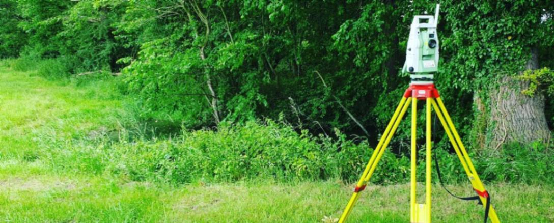
- Precision Data Capture – Using robotic total stations to record high-precision coordinates and elevations for every notable feature on the site.
- 3D Laser Scanning – Collecting millions of individual data points to create a dense point cloud for complex structural or terrain analysis.
- GNSS Satellite Positioning – Utilising Global Navigation Satellite Systems to establish accurate geospatial control points linked directly to the national grid.
- Data Post-Processing – Converting raw field observations into structured digital drawings that allow for seamless architectural and engineering integration.
What Types Of Topographical Surveys Can Be Provided?
Various configurations of topographical surveyors' services can be requested depending on the specific accuracy standards and outcomes needed:
- Standard Terrain Mapping – Delivering essential land data and level information required for planning applications and basic residential site design.
- Detailed Engineering Surveys – Providing millimetre-accurate data for complex urban sites where structural tolerances for new buildings are extremely tight.
- UAV Aerial Photogrammetry – Utilising drones to map large or inaccessible areas quickly, producing high-resolution orthophotos and digital elevation models.
- Subsurface Utility Integration – Combining topographical data with underground service information to create a unified map for safe excavation and piling works.
- 3D Topographical Modelling – Delivering data in Revit or BIM formats to support modern construction workflows and advanced architectural visualisation.
Which Industries And Projects Require Topographical Surveyors?
Multiple professional sectors rely on topographical surveyors to provide the foundational data for their physical assets, including architectural practices and civil engineering firms.
Real estate developers require accurate layouts to maximise building density, while local government authorities commission surveys for school expansions. For environmental consultants, the data is essential for flood risk assessments, ensuring that all new developments meet the necessary regulatory safety and compliance targets.
How Quickly Can Topographical Surveyors Deliver Survey Data?
Professional topographical surveyors can typically deliver completed site data within three to five working days for standard residential or small commercial plots. The speed of delivery is influenced by the complexity of the terrain and the prevailing weather conditions, which can impact laser-based measurements.
This efficiency ensures your design cycle stays on track, providing your team with the high-resolution plans needed to advance the project without unnecessary administrative delays.
What Accuracy Standards And Regulations Apply To Topographical Surveyors?
All topographical surveyors follow recognised UK standards, most notably the RICS Professional Statement for land surveys and mapping. Adhering to these regulations ensures that the survey is legally defensible and provides the geospatial precision required by structural engineers.
These standards dictate the required horizontal and vertical tolerances, providing the insurance-backed certainty that developers demand when they are funding or protecting high-value land investments.
Contact Topographical Surveyors for a consultation to get topographical surveys tailored to your organisation’s risks and responsibilities.
★★★★★
"We hired Topographical Surveyors for a detailed land survey and were extremely impressed with the professionalism of the team. They worked efficiently on-site and delivered highly accurate data within the agreed timeframe. Communication throughout the project was clear and responsive. The quality of the survey information greatly assisted our planning and design process."
Jordyn Maddox
London
★★★★★
"The Topographical Surveyors provided an excellent service from start to finish. The staff were knowledgeable, punctual, and carried out the survey with great attention to detail. All drawings and reports were professionally presented and easy to understand. Their expertise and reliability made the entire process straightforward and stress-free."
Lyric Collins
London
★★★★★
"Our experience with the Topographical Surveyors was outstanding throughout the project. The team demonstrated a high level of skill and professionalism while working on a complex site. They completed the survey efficiently and ensured all information provided was accurate and comprehensive. We would confidently use their services again in the future."
Xzavier Watson
London
★★★★★
"We used Topographical Surveyors for a commercial development project and were very satisfied with the service provided. The team was courteous, organised, and kept us informed at every stage of the work. The final survey data was delivered promptly and exceeded our expectations in terms of quality and detail. Their commitment to excellent service was evident throughout."
Zahir Decker
London
Our Locations
We are proud to work nationally across the UK, allowing us to ensure we can provide services to you.
For a full list of counties we cover in the UK, see below.